A powerful round of thunderstorms swept across North Texas on the morning of June 19, 2026, bringing torrential rainfall that overwhelmed drainage systems, flooded major highways, stranded drivers, and triggered dozens of emergency rescues throughout the Dallas-Fort Worth metroplex.
The intense weather event arrived during the height of the morning commute, creating dangerous travel conditions and disrupting transportation across the region. Several inches of rain fell within a matter of hours, leaving emergency crews scrambling to respond as roads disappeared beneath rapidly rising water.
Although the worst of the storms eventually moved out of the area, the impact was felt throughout the day as officials worked to manage flooded roadways, delayed flights, and ongoing river concerns.
Heavy Rain Arrives Before Sunrise
The storms developed early Friday morning and quickly intensified as they moved across North Texas.
Meteorologists reported rainfall totals ranging from 2 to 5 inches in many locations, with some areas experiencing rainfall rates approaching 2 inches per hour. Such intense precipitation overwhelmed drainage infrastructure and caused water to accumulate faster than it could drain away.
Drivers heading to work encountered rapidly changing conditions, with some roads becoming flooded within minutes.
The combination of heavy rain and rush-hour traffic created a challenging situation for commuters across the metro area.
Major Highways Become Impassable
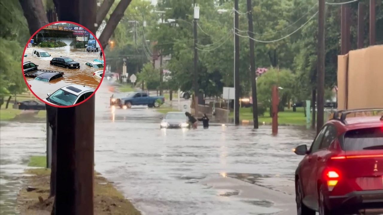
Several of the region’s busiest transportation corridors experienced severe flooding.
Sections of Interstate 35 through Dallas and Denton County became heavily congested as standing water forced lane closures and slowed traffic. The Woodall Rodgers Freeway also experienced significant flooding issues that affected vehicle movement during the busiest travel period of the day.
The Dallas North Tollway saw similar problems, particularly in southbound lanes where water accumulated quickly.
Motorists reported seeing vehicles stalled in deep water while emergency responders worked to reach stranded drivers.
Many commuters faced lengthy delays as authorities attempted to manage traffic around flooded areas.
Underpasses Disappear Under Water
Some of the most dramatic scenes occurred at low-lying underpasses throughout Dallas.
Areas near Northwest Highway, Walnut Hill, and Carol Avenue became completely submerged after heavy runoff poured into roadways. Several underpasses that normally carry thousands of vehicles each day transformed into temporary lakes.
Officials quickly closed affected areas to prevent additional motorists from becoming trapped.
Flooded underpasses remain among the most dangerous locations during flash flooding events because water depths can increase rapidly without warning.
Authorities repeatedly reminded drivers to avoid attempting to cross flooded roads regardless of how shallow the water might appear.
Emergency Crews Face Busy Morning
The scale of the flooding created an enormous workload for emergency responders.
Dallas Fire-Rescue reported receiving dozens of calls involving vehicles trapped in rising water. The department ultimately responded to 76 vehicle-in-water incidents during the storm.
The demand for assistance became so significant that all 59 active fire engines were assigned to emergency flood-related calls.
Rescue crews worked throughout the morning to reach stranded motorists and assist individuals whose vehicles had become disabled in deep water.
The operation highlighted the challenges emergency personnel face during sudden flash flooding events in densely populated urban areas.
Drivers Rescued Across Metroplex
Many drivers found themselves trapped after water levels rose faster than expected.
Some motorists attempted to navigate flooded roadways only to discover that their vehicles quickly became disabled. Others were caught by rapidly rising water while traveling through underpasses and low-lying sections of road.
Emergency responders conducted multiple water rescues throughout the morning, helping people reach safety while avoiding more serious outcomes.
Officials credited quick response times and public cooperation for preventing additional injuries during the event.
The rescues also served as another reminder of the dangers associated with driving through floodwaters.
Self-Driving Cars Face Unexpected Challenge
The flooding created difficulties not only for human drivers but also for autonomous vehicles operating in Dallas.
Several self-driving vehicles encountered problems as they attempted to navigate roads affected by standing water. Videos and eyewitness reports showed autonomous cars struggling to determine safe routes through flooded streets.
While advanced vehicle technology continues to evolve, extreme weather remains one of the most difficult situations for both human and automated transportation systems.
The incidents highlighted how rapidly changing weather conditions can challenge even the most sophisticated navigation technologies.
Airports Experience Major Delays
The storm’s impact extended well beyond highways and city streets.
Air travel across North Texas suffered significant disruptions as thunderstorms moved through the region. Ground stops, delayed departures, and changing weather conditions forced airlines to adjust operations throughout the day.
Dallas-Fort Worth International Airport experienced nearly 400 flight cancellations, affecting thousands of travelers.
Dallas Love Field also reported dozens of canceled flights as carriers worked to manage weather-related disruptions.
Passengers faced long waits, schedule changes, and travel uncertainty as airport operations gradually returned to normal.
Schools and Events Affected
The flooding also disrupted daily activities beyond transportation.
Southern Methodist University issued flash flood alerts and temporarily closed sections of Bishop Boulevard because of hazardous conditions. Students, faculty, and visitors were urged to avoid flooded areas until water levels receded.
Meanwhile, city officials were forced to delay the opening of the FIFA World Cup Fan Fest at Fair Park.
Organizers postponed activities until weather conditions improved and public safety concerns could be addressed.
The delays demonstrated how widespread the storm’s impact became across multiple sectors of the city.
River Concerns Continue
Although flash flood warnings eventually expired, concerns did not disappear once the rain stopped.
Water from the storms continued flowing into local waterways, prompting ongoing monitoring of river and creek levels. Officials maintained flood-related alerts for portions of White Rock Creek and the Trinity River as runoff continued moving through the system.
Hydrologists warned that elevated water levels could persist even after skies cleared.
Residents living near waterways were encouraged to remain aware of changing conditions and monitor official updates.
Heat Returns After the Storms
Ironically, the flooding was quickly followed by another familiar North Texas weather challenge.
Forecasters indicated that extreme summer heat would return shortly after the storms departed. Heat index values were expected to climb back into the 105 to 110-degree range as sunshine and humidity returned to the region.
This rapid transition from flooding to dangerous heat highlighted the highly variable weather patterns often experienced during Texas summers.
Officials Urge Flood Safety
As recovery efforts continued, emergency management officials emphasized an important message: never drive through flooded roadways.
The National Weather Service’s well-known “Turn Around, Don’t Drown” campaign remains one of the most effective safety reminders during flash flooding events.
Even a small amount of moving water can carry away a vehicle, while deeper water may hide roadway damage or dangerous debris.
While North Texas has begun recovering from the June 19 storms, the event serves as another example of how quickly severe weather can disrupt daily life and create hazardous conditions across one of the nation’s largest metropolitan regions.